
City
Ciudad Nezahualcoyotl
Mexico
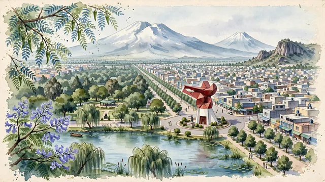
What guided this image
- Landmarks
- Coyote's Head; Nezahualcóyotl; Parque del Pueblo; Cerro de Chimalhuacán; Popocatépetl and Iztaccíhuatl; lush high-plateau flora; Valley of Mexico
- Viewpoint
- Favor the classic viewpoint looking southeast across the city toward the Coyote sculpture or from Parque del Pueblo looking toward the volcanoes, showing pepper tree branches and park foliage in the foreground, the sweeping avenue, the bold geometric Coyote head, and low-rise rooftops in the middle-ground, and the colossal, snow-capped peaks of Iztaccíhuatl and Popocatépetl rising in the background.
- Palette
- Green should be the predominant color, especially in the thick canopies of Parque del Pueblo, pepper trees (pirul) along avenues, and eucalyptus groves.
- Guarded against
- Not central Mexico City, Guadalajara, or Puebla
Population1,077,208Wikidata: 1,072,676
Coordinates19.40°N, 99.01°W
Elevation2,870 m
Area63,440,000 km²
Time zoneAmerica/Mexico_CityUTC−6
Solar noon12:36clock runs 0.6 h ahead of the sun
Through the Earth
Dig straight through the Earth from Ciudad Nezahualcoyotl and you surface in open ocean, nearest to Seabreeze village, British Indian Ocean Territory — 1,636 km from the exact antipodal point.
Nearest cities in the atlas
| Iztapalapa | MX | 7 km |
| Mexico City | MX | 13 km |
| Ecatepec de Morelos | MX | 23 km |
| Puebla | MX | 93 km |
| Santiago de Querétaro | MX | 196 km |
| León de los Aldama | MX | 338 km |
| Guadalajara | MX | 475 km |
| Zapopan | MX | 480 km |
Twinned cities
Wikidata records no twinned cities for Ciudad Nezahualcoyotl inside this atlas.