
City
Bangkok
Capital of Thailand
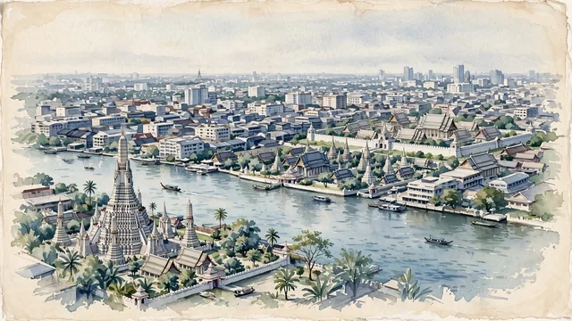
What guided this image
- Landmarks
- Wat Arun; Wat Pho; The Grand Palace and Wat Phra Kaew; Historic
- Viewpoint
- Use an elevated oblique view from the southwest side of the Wat Arun area across the river toward Rattanakosin, allowing the familiar river temples to sit within their actual separate compounds rather than a single compressed tourist collage.
- Palette
- Muted botanical green should predominate in the real temple-ground planting and river reflections, with blue-green water, slate-grey roofs and pale neutral temple surfaces holding the broader city together.
- Guarded against
- Avoid making Bangkok look like Angkor with ruins in a jungle, Bali with rice terraces and volcanoes, or Hong Kong with steep mountains pressed against a deep harbor.
Population5,104,476Wikidata: 8,280,925
Coordinates13.75°N, 100.50°E
Elevation2 m
Area1,569 km²
Time zoneAsia/BangkokUTC+7
Solar noon12:18clock runs 0.3 h ahead of the sun
Through the Earth
Dig straight through the Earth from Bangkok and you surface nearest to Callao, Peru — 319 km from the exact antipodal point.
Nearest cities in the atlas
| Vientiane | LA | 520 km |
| Phnom Penh | KH | 538 km |
| Yangon | MM | 577 km |
| Cần Thơ | VN | 708 km |
| Ho Chi Minh City | VN | 741 km |
| Biên Hòa | VN | 754 km |
| Nay Pyi Taw | MM | 813 km |
| Huế | VN | 820 km |
Twinned cities
- Ankara TR
- Astana KZ
- Beijing CN
- Brisbane AU
- Budapest HU
- Busan KR
- Chaozhou CN
- Chongqing CN
- Fukuoka JP
- Guangzhou CN
- Hanoi VN
- Istanbul TR
- Jakarta ID
- Manila PH
- Moscow RU
- Phnom Penh KH
- Saint Petersburg RU
- Seoul KR
- Shanghai CN
- Tehran IR
- Tianjin CN
- Vientiane LA
- Washington US
- Wuhan CN
24 of 29 twinned cities are in this atlas. See the full network →