
City
Canberra
Capital of Australia
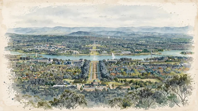
What guided this image
- Landmarks
- Australian War Memorial; Australian War Memorial; Captain Cook Memorial Jet; Old Parliament House; Parliament House; Black Mountain; National Carillon; Brindabella Ranges
- Viewpoint
- Favor a slightly elevated viewpoint from Mount Ainslie, looking south-west down Anzac Parade across Lake Burley Griffin toward Old Parliament House and Parliament House, with Black Mountain to the right and the Brindabella Ranges beyond.
- Palette
- Green should be the predominant color, especially in the eucalyptus woodland, the hills, the lakeside parkland, and the overall visual impression.
- Guarded against
- Avoid making Canberra look like Sydney, Washington, D.C., or a European capital, and avoid Mediterranean or Alpine character.
Population367,752Wikidata: 381,488
Coordinates35.28°S, 149.13°E
Elevation578 m
Area472 km²
Time zoneAustralia/SydneyUTC+11
Solar noon13:03clock runs 1.1 h ahead of the sun
Through the Earth
Dig straight through the Earth from Canberra and you surface nearest to Castelo Branco, Portugal — 408 km from the exact antipodal point.
Nearest cities in the atlas
| Sydney | AU | 247 km |
| Melbourne | AU | 467 km |
| Brisbane | AU | 944 km |
| Adelaide | AU | 958 km |
| Auckland | NZ | 2,303 km |
| Wellington | NZ | 2,327 km |
| Port-Vila | VU | 2,718 km |
| Port Moresby | PG | 2,876 km |
Twinned cities
6 of 8 twinned cities are in this atlas. See the full network →