
City
Brasília
Capital of Brazil
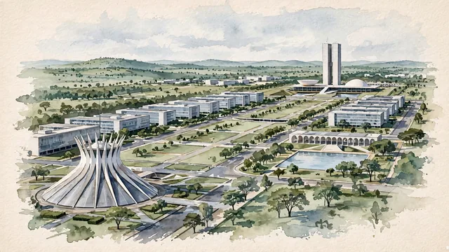
What guided this image
- Landmarks
- The National Congress; The Cathedral of Brasília; Itamaraty Palace; The Esplanade of Ministries
- Viewpoint
- Use a moderately elevated eastward oblique view along the Esplanade, a familiar monumental-axis perspective that must retain the real broad spaces and adjoining ministry blocks instead of assembling Niemeyer’s buildings into a compact sculpture garden.
- Palette
- Muted botanical green should predominate in the planned lawns and actual tree groups, with pale paper reserved for concrete, slate-grey structural shadows and blue-grey glazing maintaining the city’s modernist clarity.
- Guarded against
- Avoid making Brasília look like Rio de Janeiro with granite coastal mountains, Salvador with a colorful colonial center, or Dubai with a dense collection of unrelated supertall towers.
Population2,207,718Wikidata: 2,789,761
Coordinates15.78°S, 47.93°W
Elevation1,171 m
Area5,802 km²
Time zoneAmerica/Sao_PauloUTC−3
Solar noon12:12clock runs 0.2 h ahead of the sun
Through the Earth
Dig straight through the Earth from Brasília and you surface in open ocean, nearest to San Policarpo, Philippines — 813 km from the exact antipodal point.
Nearest cities in the atlas
| Goiânia | BR | 173 km |
| Belo Horizonte | BR | 625 km |
| Campinas | BR | 798 km |
| Guarulhos | BR | 866 km |
| São Paulo | BR | 874 km |
| Rio de Janeiro | BR | 936 km |
| Salvador | BR | 1,063 km |
| Curitiba | BR | 1,082 km |
Twinned cities
- Abuja NG
- Amsterdam NL
- Berlin DE
- Bogotá CO
- Brussels BE
- Buenos Aires AR
- Canberra AU
- Doha QA
- Guadalajara MX
- Khartoum SD
- Kyiv UA
- Lima PE
- Lisbon PT
- Maputo MZ
- Montevideo UY
- New York City US
- Rome IT
- Santiago CL
- Tehran IR
- Vienna AT
- Washington US
- Xi’an CN
22 of 26 twinned cities are in this atlas. See the full network →