
City
Buenos Aires
Capital of Argentina
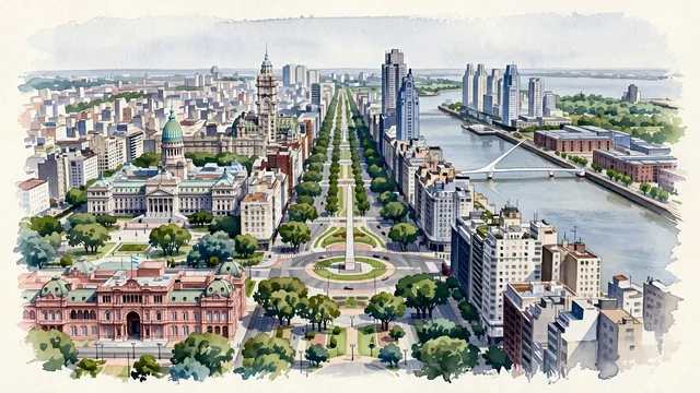
What guided this image
- Landmarks
- Obelisco; Palace of the Argentine National Congress; Palacio Barolo and the Kavanagh Building; Puente de la Mujer; Catalinas Norte; Plaza de Mayo; Parisian-style Beaux-Arts and Art Nouveau; Palermo
- Viewpoint
- Favor a slightly elevated viewpoint above the city center, looking east across the dense grid and Avenida 9 de Julio with the Obelisco toward Puerto Madero and the flat horizon of the Río de la Plata.
- Palette
- Green should be the predominant color, especially in the street trees, the avenue medians, the parks, the Congress dome, and the overall visual impression.
- Guarded against
- Avoid making Buenos Aires look like Paris, Madrid, Barcelona, or Rio de Janeiro, and avoid Mediterranean or tropical-beach character.
Population2,891,082Wikidata: 466,300
Coordinates34.61°S, 58.38°W
Elevation25 m
Area203 km²
Time zoneAmerica/Argentina/Buenos_AiresUTC−3
Solar noon12:54clock runs 0.9 h ahead of the sun
Through the Earth
Dig straight through the Earth from Buenos Aires and you surface nearest to Zhendong, China — 139 km from the exact antipodal point.
Nearest cities in the atlas
| Montevideo | UY | 203 km |
| Córdoba | AR | 648 km |
| Porto Alegre | BR | 843 km |
| Asunción | PY | 1,039 km |
| Santiago | CL | 1,137 km |
| Curitiba | BR | 1,344 km |
| São Paulo | BR | 1,675 km |
| Guarulhos | BR | 1,690 km |
Twinned cities
- Athens GR
- Barcelona ES
- Barranquilla CO
- Beijing CN
- Beirut LB
- Belgrade RS
- Berlin DE
- Bogotá CO
- Brasília BR
- Cairo EG
- Cape Town ZA
- Damascus SY
- Istanbul TR
- Kyiv UA
- La Paz BO
- Lima PE
- Lisbon PT
- London GB
- Madrid ES
- Medellín CO
- Mexico City MX
- Milan IT
- Montevideo UY
- Moscow RU
- Osaka JP
- Ottawa CA
- Porto Alegre BR
- Prague CZ
- Quito EC
- Ramallah PS
- Rio de Janeiro BR
- Saint Petersburg RU
- Santiago CL
- Santo Domingo DO
- São Paulo BR
- Seoul KR
- Warsaw PL
- Yerevan AM
- Zagreb HR
39 of 68 twinned cities are in this atlas. See the full network →